
The power to explore and navigate throughout the known world and beyond was once restricted to mythological heroes or those of extraordinary ability. When the U.S. was in an arms race with Russia during the Cold War, the U.S. strove to gain an edge in the competition through technological superiority. In doing so the United States would push their scientists and resources to harness the ability of geolocation through innovative technologies. Before the 20th century, navigation required a suite of tools and skills taking many years to master: the ability to chart the movements of the stars, sun, and moon; access to maps, compasses, and local knowledge; or the use of landmarks, natural signs, and deduction were the most efficient tools for navigation in the United States. Space age technology in the form of the Global Positioning System (GPS) presented a transformational change to society by allowing untrained individuals to perfectly assess their location with a single piece of equipment. Then the 2007 invention of a Wireless Network Assisted GPS System improved upon the use of GPS.
The Wireless Network Assisted GPS System is described in its patent abstract as “A method and apparatus for locating a mobile communications device such as a cell phone includes apparatus for communicating with base stations and apparatus for communicating with satellites. Signals received from satellites and the base stations are combined to provide the necessary information to calculate the location of the mobile communications device.” The Wireless Network Assisted GPS System is specifically tied to a mobile communications device such as a cell phone. This innovative technology is dependent on NASA’s initiative that released numerous satellites into Earth’s orbit during the Cold War. This was an effort to extend the eyes and ears of the State Department and Department of Defense. These satellites would later become the backbone of most telecommunication technologies and industries in America. The maturation of satellite technology in this period would facilitate the development of the GPS satellite constellation.[i]
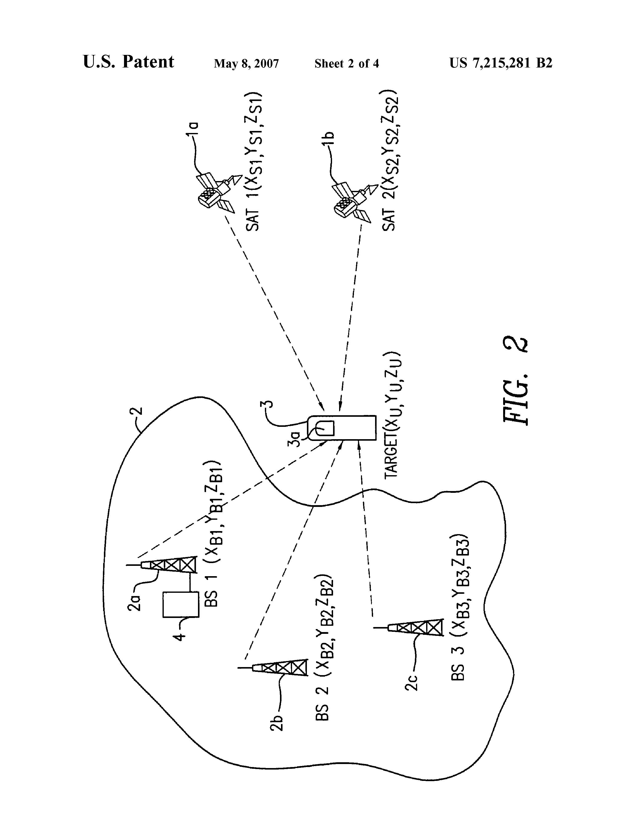
Today, most people regard the term GPS as a receiver device. Yet, GPS is a space-based navigation system composed of over two dozen different satellites perpetually orbiting the earth. The GPS receiver’s job is to communicate with the satellites to deduce its location by determining the distance from multiple satellites and the mobile unit as assisted by a wireless network, such as the Wireless Network Assisted GPS System. Determining the distance to different satellites with a known position allows for the location of the receiver to be deduced by triangulation. Timing is important to this process because distance is determined by the travel time of the signal.
The Wireless Network Assisted GPS System is a non-obvious utility to one reasonably skilled in the art, making it qualified to receive a patent. The patent is for a hybrid GPS system technology, where the position of a mobile unit is estimated using an existing wireless network. Inventor Sirin Tekinay (formerly Associate Professor in the Electrical and Computer Engineering Department at the New Jersey Institute of Technology) and her PhD student, Woo-Jin Choi, created an innovative geolocation technology resolving timing errors, effectively detecting GPS signals, and resolving power consumption issues. Differential GPS technology helps resolve timing errors via a “stationary reference receiver, which uses its known position to calculate timing” (US7215281B2). But Tekinay and Choi’s wireless innovation more effectively detects GPS signals and, by acting as a ground based relay, has solved or minimized the problems that occur in blocked connections from satellites to receivers.
Cited in patent continuity is the “GPS receiver utilizing a communication link,” from 1998 (US5841396). This GPS receiver was one of the earliest inventions involving GPS technology. Much of the science is similar in these two patents, because the Wireless Network Assisted GPS system is using the technology offered by the GPS receiver utilizing a communication link. Yet, the novelty of the Wireless Network Assisted GPS System relates to a geolocation technology, specifically a hybrid GPS system in which positioning of a mobile unit is realized with the assistance of a wireless network. This resolved difficulties of battery consumption and signal acquisition by having the ground based wireless network perform the computations necessary to resolve timing errors and act as a stepping stone to identify the location of the GPS receiver.
By Zachary Valbrun, Nikolette Petteway, and Abhishek Bose
[i] Dunbar, Brian. “Global Positioning System History.” NASA, NASA, 5 May 2015, www.nasa.gov/directorates/heo/scan/communications/policy/GPS_History.html.